
Hotline: 015 59 55 98
088 5999 009


GARMIN


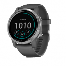
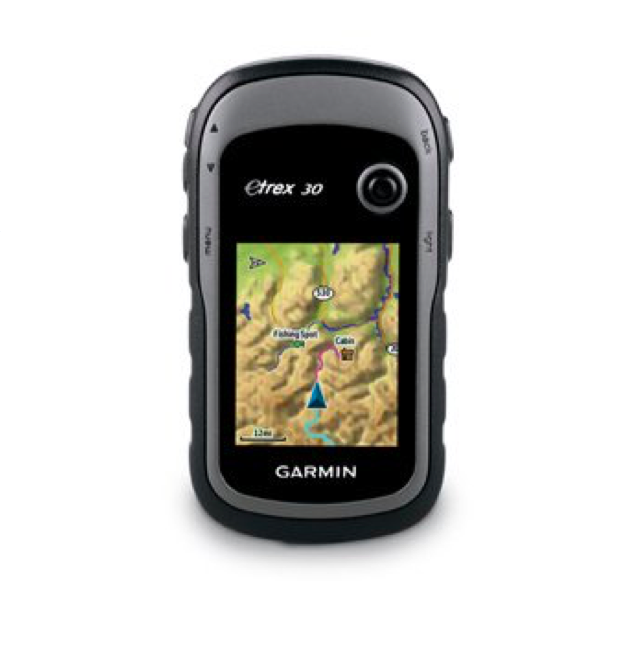
eTrex 30 takes one of the most popular and reliable GPS handhelds and makes it better. Enhanced ergonomics, an improved interface, paperless geocaching and expanded mapping capabilities makes eTrex more versatile and user-friendly, while maintaining its toughness and durability.
eTrex 30 has an enhanced 2.2", 65K color, sunlight-readable display. Durable and water resistant, eTrex 30 is built to withstand the elements. It has an upgraded interface and stands strong against dust, dirt, humidity or water.
eTrex 30 adds a built-in 3-axis tilt-compensated electronic compass, which shows your heading even when you’re standing still, without holding it level. Also added is a barometric altimeter which tracks changes in pressure to pinpoint your precise altitude, and you even can use it to plot barometric pressure over time, which can help you keep an eye on changing weather conditions.
With an array of compatible mounts, eTrex 30 is designed for use on ATVs, bicycles, in boats, as a handheld or in your car. Use the auto mount capability and City Navigator NT® maps for turn-by-turn driving directions, or the rugged mount for your motorcycle or ATV. Wherever you think you might take eTrex, it has the mapping and mounts to get you there.
eTrex is the first-ever consumer-grade receiver that can track both GPS and GLONASS satellites simultaneously. GLONASS is a system developed by the Russian Federation that will be fully operational in 2012. When using GLONASS satellites, the time it takes for the receiver to “lock on” to a position is (on average) approximately 20 percent faster than using GPS. And when using both GPS and GLONASS, the receiver has the ability to lock on to 24 more satellites than using GPS alone.
With its microSD™ card slot and 1.7 GB of internal memory, eTrex 30 lets you load TOPO 24K maps and hit the trail, plug in BlueChart® g2 preloaded cards for a great day on the water or City Navigator NT map data for turn-by-turn routing on roads (see maps tab for compatible maps). eTrex 30 also supports BirdsEye Satellite Imagery (subscription required), that lets you download satellite images to your device and integrate them with your maps.
eTrex 30 lets you share your waypoints, tracks, routes and geocaches wirelessly with other compatible devices. So now your friends also can enjoy your favorite hike or cache – simply press “send” to transfer your information.
With its high-sensitivity, WAAS-enabled GPS receiver and HotFix® satellite prediction, eTrex locates your position quickly and precisely and maintains its GPS location even in heavy cover and deep canyons.
eTrex 30 supports geocaching GPX files for downloading geocaches and details straight to your unit. Visit Geocaching.com to start your geocaching adventure. By going paperless, you're not only helping the environment but also improving efficiency. eTrex 30 stores and displays key information, including location, terrain, difficulty, hints and descriptions, which means no more manually entering coordinates and paper printouts. Simply upload the GPX file to your unit and start hunting for caches.
Take charge of your next adventure with BaseCamp™, software that lets you view and organize maps, waypoints, routes, and tracks. This free trip-planning software even allows you to create Garmin Adventures that you can share with friends, family or fellow explorers. BaseCamp displays topographic map data in 2-D or 3-D on your computer screen, including contour lines and elevation profiles. It also can transfer an unlimited amount of satellite images to your device when paired with a BirdsEye Satellite Imagery subscription.
General |
|
| PHYSICAL DIMENSIONS | 2.1" x 4.0" x 1.3" (5.4 x 10.3 x 3.3 cm) |
|---|---|
| DISPLAY SIZE | 1.4" x 1.7" (3.5 x 4.4 cm); 2.2" diag (5.6 cm) |
| DISPLAY RESOLUTION | 176 x 220 pixels |
| DISPLAY TYPE | transflective, 65-K color TFT |
| WEIGHT | 5 oz (141.7 g) with batteries |
| BATTERY TYPE | 2 AA batteries (not included); NiMH or Lithium recommended |
| BATTERY LIFE | 25 hours |
| WATER RATING | IPX7 |
| HIGH-SENSITIVITY RECEIVER | |
| MEMORY/HISTORY | 1.7 GB |
Maps & Memory |
|
| ABILITY TO ADD MAPS | |
|---|---|
| BASEMAP | |
| AUTOMATIC ROUTING (TURN BY TURN ROUTING ON ROADS) | Yes (with optional mapping for detailed roads) |
| EXTERNAL MEMORY STORAGE | microSD™ card (not included) |
| WAYPOINTS/FAVORITES/LOCATIONS | 2000 |
| TRACK LOG | 10,000 points, 200 saved tracks |
| ROUTES | 200 |
Sensors |
|
| BAROMETRIC ALTIMETER | |
|---|---|
| COMPASS | Yes (tilt-compensated 3-axis) |
Outdoor Recreation |
|
| AREA CALCULATION | |
|---|---|
| HUNT/FISH CALENDAR | |
| SUN AND MOON INFORMATION | |
| GEOCACHING-FRIENDLY | Yes (Paperless) |
| CUSTOM MAPS COMPATIBLE | |
| PICTURE VIEWER | |